Showing posts with label Apache Junction. Show all posts

Monday, February 10, 2014

Hiking the Lost Dutchman State Park

The Superstition Mountains have been a source of mystery and legend since early times. The area is dotted with ancient cliff dwellings and caves, many showing signs of former habitation by a number of different Native American groups, up until the 1800's. We visited the cliff dwellings on our drive through the mountains.

During the 1840's, the Peralta family of northern Mexico supposedly developed a rich gold mine in the Superstitions. According to legend, an Apache ambush ended the family's last expedition, and the gold remained in the area. In the 1870's, Jacob Waltz ("the Dutchman") was said to have located the mine with the aid of a Peralta descendant. Waltz and his partner, Jacob Weiser, worked in the mine and allegedly hid one or more caches of gold in the Superstitions.

After Waltz's death in 1891, several people attempted to seek out the Lost Dutchman's Mine, all without luck. Later searchers sometimes met with foul play or even death, contributing to the superstition and legend of these mountains.

So this seemed like an excellent spot to go for a closer look at the mountains. There are several hikes on the park's map with varying degrees of difficulty. We chose the Treasure Loop Trail - a 2.4 mile hike to an elevation of 2580 feet. Rated as moderate it seemed very do-able to us.
The "X" marks our goal
So we put on our hiking shoes, took water and a walking pole and off we went.
The saguaro cactus Arch is standing by is pretty scarred and pretty old. These huge plants are found only in Arizona and Mexico and weigh about 100 pounds per foot.

The views on the way up were spectacular:
And the trail was very well groomed:
X marks the top of the trail
And there were a couple of rest spots
But near the top it got pretty tricky:
Phew! We made it:
Top of the trail
The way down was much easier:
But you still need to be careful and the walking pole helps a lot. We bought the poles at a swap meet (the Arizona term for a flea market) for $7 each. And so far they seem to be every bit as good as the $100 a pair ones we buy in Canada. Time will tell.

We met these horseback riders on their way up:
That is the state park camp ground in the left of the picture. You can just see the top of the RVs parked there. A beautiful spot.

The views in this area are so vast and spectacular. One never gets tired of them. So different from the "small and incredibly beautiful" landscapes we are accustomed to in Nova Scotia.
Half-way down the trail. 

To enlarge the pictures simply left click on them
You can follow more of our adventures on our facebook page
To contact me click here 
We enjoy and appreciate your comments. To comment simply click on the comments link below.

Thursday, February 6, 2014

A Day in the Superstition Mountains

Apache Junction, Arizona is situated at the base of the Superstition Mountains.
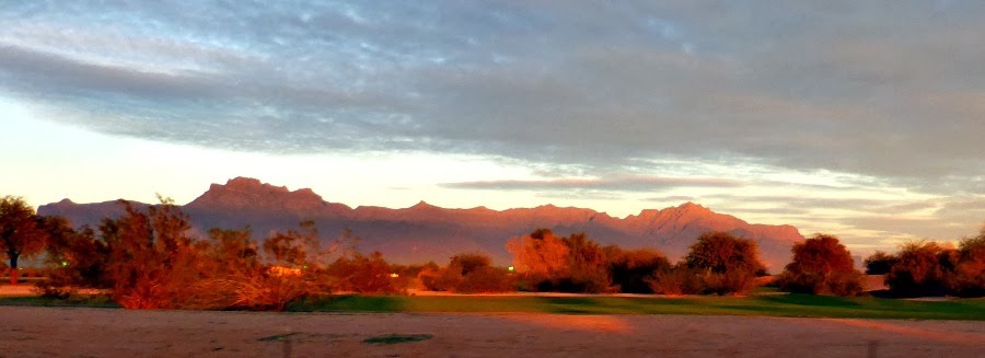
Sun setting on the Superstition Mountains
These mountains have long been a place of unexplained paranormal stories and thus the name. We set out to explore them as soon as I returned from Montreal. First stop was a museum that explained the history of the area. While there we met a couple who told us the best way to see the mountains was to take a 100 mile circular drive through the mountains with a side trip to see the world's largest copper mine. (We've learned that everything is the "worlds largest or best" here in the US).
 So off we went into the mountains:
First stop. The copper mine. The mining company was kind enough to provide a viewing area where we could get a good look into the mine and some information panels telling us about the mine.
Below is a panorama of the mine 
It was impossible to get a picture of of the complete mine with my camera. Below is a photo showing very large trucks working down in the mine. They are like the huge trucks used in the oil sands.
And this is a fly over photo of the mine from one of the panels:
It is large indeed!

We left the mine, and headed further into the mountains and the Tonto National Forest. There were a lot of mining operations along our drive:
And then we came to the Tonto National Monument. An area preserved by the Federal Government because it contains cliff dwellings occupied in the 13th, 14th and early 15th centuries. 

It looked like a long way up but worth the climb:
Cliff dwellings are at the red X in the upper left corner
So after reading these rules we were off:
Add caption
The saguaro cactus in this area are huge:
As we were at a pretty high altitude stopping for a lot of breaks was a must:
About half way up
Finally close to the top. The people on the trail in the lower right will give you some idea of the size of the cliffs.

You can see the rooms inside the cave
It was very impressive to see what the Salado did with so little.
Then we headed back down to the car:
And on to Roosevelt Lake. You can see the lake in the distance above. When we were driving across the Arizona desert towards Phoenix a truck pulling a fairly large boat passed us:
We couldn't help but wonder what they were going to do with a boat in the middle of the desert. Now we know:
Roosevelt Lake is located in the Tonto Basin and was created by the Roosevelt Dam:

A beautiful bridge spanned the entrance to the dam area. Its story is very interesting:
I hope you can read the information. Left click to enlarge. Or read more about it's construction here.
 My photo of the bridge:
We then crossed the bridge and headed back to Apache Junction - a beautiful drive through the mountains.

To enlarge the pictures simply left click on them
You can follow more of our adventures on our facebook page
To contact me click here 
We enjoy and appreciate your comments. To comment simply click on the comments link below.
Wednesday, February 5, 2014

Driving to Phoenix

It took us three days to drive from San Antonio to Phoenix - about 1000 miles across the desert, with a few mountains thrown in. Very much against our 4-4-2 driving rule (quit after 4 hours, 4 pm or 200 miles - whichever comes first) but I was anxious to get settled there and head for Montreal, so we did it.

As we left San Antonio we quickly got a feel for how big Texas really is:
Rolling hills and expansive views
The mountains you see in the distance are the Davis Mountains, which are north of Big Bend National Park.

As we entered the mountains there was a scenic look-off. We stopped to check out the scenery. The view point was actually at the top of a pretty high climb but I decided to hike up quickly and take a look. Did not realize we were at an elevation of about 4000 ft. and the air was getting thin - thought I was having a heart attack half way up - then it registered that we were at a higher elevation than we are accustomed to. So I slowed down and made it to the top. The view was worth it:
That is the Adventure Bus down in the pull off
On the other side of the Davis Mountains we entered the desert:
And eventually passed by El Paso:
Downtown El Paso
The only city or town of any size between San Antonio and Phoenix.
El Paso subdivision
And crossed into New Mexico:

We originally planned to spend two weeks in New Mexico but that was not to be. And that is probably a good thing - the elevation in New Mexico is high and it is cold there.  But beautiful. This is the  view from the RV park where we stopped on night 2:
 The next day we drove past many pecan farms:

Through a lot of desert landscape until we entered Arizona and more desert:
When we arrived in the Phoenix area Arch's nephew, Fraser, who spent several winters there, met us and showed us several RV parks. He had already put our names in to hold a site in La Hacienda RV Resort in Apache Junction.. Which turned out to be the best of the bunch - he has excellent taste - and we checked in there for the rest of January.
Another great RV resort - very nice people manage it and the people in the resort were great. Arch connected with fellow golfers and played a lot of golf while I was away. Note all the trees - very unusual in RV parks in this area.

To enlarge the pictures simply left click on them
You can follow more of our adventures on our facebook page
To contact me click here 
We enjoy and appreciate your comments. To comment simply click on the comments link below.